There’s a free public database that contains the GPS location of 1.7 billion WiFi networks. Right now your router is almost certainly in it. A volunteer with a phone recorded it from the street, uploaded it to a shared database, and moved on. They’ve been doing this since 2001.
This is wardriving. You put the WiGLE Android app on your phone, go for a drive, and it silently logs every WiFi signal it detects — network name, encryption type, signal strength, and GPS coordinates — then uploads them to a shared global database. The signals come from your router broadcasting into the street 24 hours a day. No hacking, no cracking — just listening. Same data your phone already sees when it shows you available networks.
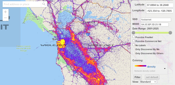
WiGLE.net is where it all lives. The Wireless Geographic Logging Engine, running since September 2001. Free to browse. The heatmap of any city shows WiFi density at a glance — rural highway through Kansas: almost nothing, Manhattan: solid wall of cyan. It’s one of the longest-running volunteer mapping projects on the internet, predating Google Maps by three years.
The current totals: 1.7 billion WiFi networks mapped. 4.5 billion Bluetooth devices. 28 million cell towers. 658,000 contributor accounts. Every major city in the world has been covered. Some contributors have logged tens of millions of networks over years of daily drives.
The historical data tells its own security story. When wardriving started in 2001, most WiFi networks were unencrypted — you could join your neighbor’s network by accident. Today WiGLE shows only 1.84% of logged networks have no encryption at all. WPA3, the current strongest standard, is at 3.22% and climbing. Twenty-five years of home router security history sits in this database.
If you’d rather your router wasn’t in there, WiGLE has a privacy opt-out. Submit your MAC address (labeled “BSSID” on the back of your router) and the network gets removed from the public database. Most people don’t bother — the same data is in your ISP’s logs, Google’s Street View scans, and Apple’s location database anyway.
The today-days-old realization is that this has been running for 25 years, built entirely by volunteers, with no corporate backing. A self-organized community mapping the wireless infrastructure of civilization because they thought it was interesting and worth knowing. The heatmap alone is worth the visit. Go check your city at wigle.net.